Skip to product information


Topographic Maps Complete Lesson Plan - Grades 6-8
$13.20
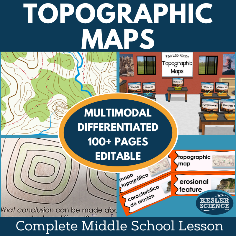
This complete unit gives middle school teachers everything they need to teach topographic maps in an engaging, student-centered way. Students explore how to interpret contour lines, identify landforms and erosional features using satellite views, and predict changes caused by weathering. The lesson includes editable presentations, worksheets, student-choice projects, a differentiated station lab, and assessments. Designed for multiday instruction with minimal prep, it emphasizes student-led learning while allowing teachers to focus on supporting mastery.
Essential Questions for Students
-
How are topographic maps interpreted?
-
How do satellite views identify land and erosional features?
-
How can changes caused by weathering be predicted?
Key Features
-
Differentiated materials to support students with varied needs
-
Multimodal activities to maintain engagement and meet learning styles
-
Flexible implementation in both printable and digital formats
-
Editable PowerPoints for teacher customization
-
Spanish translations of vocabulary, a station lab passage, and interactive notebook pages
Instructional Framework: The 5E Model
This lesson is structured around the 5E instructional model—Engage, Explore, Explain, Elaborate, Evaluate—balancing inquiry, practice, and assessment.
Engage
-
Objectives and Word Wall cards (English & Spanish)
-
Teacher file with class discussion prompts, activities, and common misconceptions
Explore
-
A nine-station, student-led lab introduces topographic maps with differentiated, multimodal activities
Input Stations:
-
Explore It! – Hands-on demonstration or experiment
-
Read It! – Differentiated passages (English & Spanish) with comprehension checks
-
Research It! – Guided web-based activity with structured tasks
-
Watch It! – Short video with discussion prompts
Output Stations:
-
Organize It! – Card sorts and categorization (print or digital)
-
Write It! – Open-ended written responses
-
Illustrate It! – Sketching/drawing activities to reinforce retention
-
Assess It! – Vocabulary-in-context and mastery-based questions
Bonus Station:
-
Challenge It! – Crosswords, games, and mini-projects for enrichment or early finishers
Explain
-
Editable PowerPoints (standard and interactive formats)
-
Interactive Notebook templates (digital & print, English & Spanish)
-
Note-taking organizers for guided presentations
Elaborate
-
Student-choice projects on topographic maps to extend learning at home or in class
Evaluate
-
Assessments updated for STAAR 2.0, available in standard and modified formats
-
Review worksheets and questions for homework, practice, or class discussions
Flexible Learning Options
This lesson works in both in-person and virtual classrooms. The digital station lab and interactive notebook templates are fully compatible with PowerPoint and Google Slides, making it easy to adapt for blended or remote instruction.
This product is included in the Kesler Science Membership!
This is a finished product; it will be updated with formatting or corrections as needed. Future improvements and new features will be sold as a separate product.
Pickup currently not available
Terms of Use
Copyright © Kesler Science, LLC. All rights reserved by the author. This product is to be used by the original downloader only. Copying for more than one teacher, classroom, department, school, or school system is prohibited. Permission is never granted to enter Kesler Science materials into any form of AI for any purpose. This product may not be distributed or displayed digitally for public view. Failure to comply is
copyright infringement and a violation of the Digital Millennium Copyright Act (DMCA). Clipart and elements found in this PDF are
copyrighted and cannot be extracted and used outside of this file without permission or license. Intended for classroom and personal use ONLY. Multiple licenses are available for purchase by departments,
schools, or school districts. Contact support@keslerscience.com for more information.
